

Invest 90L Could Bring Torrential Rain and Gusty Winds to Louisiana and Mississippi

Invest 90L Brings Heavy Rain Threat and Strong Winds to Louisiana and Mississippi
Gulf Coast residents are keeping a close eye on Invest 90L, which is a tropical disturbance that has potential to cause heavy rain, isolated flooding, and gusty winds across parts of Louisiana and Mississippi over the next few days. The system is being monitored closely by meteorologists as it traverses through very conducive conditions, triggering concerns of possible impacts along the northern Gulf Coast.
The latest on Invest 90L is that while the system’s potential future development remains a big question mark, its impacts could be felt well before we see any kind of formation of a tropical cyclone. Forecasters said people should prepare for spells of heavy rain, gusty winds and flash flooding.
The National Hurricane Center is still watching the disturbance, and people across Louisiana and Mississippi are being advised to keep an eye on the situation, and be ready for the weather to change suddenly.
Table of Contents
- What Is Invest 90L?
- Latest Invest 90L Update
- Invest 90L Forecast and Storm Track
- Heavy Rain Threat for Louisiana
- Mississippi Weather Forecast and Potential Impacts
- Strong Winds Expected Across the Gulf Coast
- Flooding Risk in Louisiana and Mississippi
- Will Invest 90L Become a Tropical Storm?
- National Hurricane Center Monitoring Invest 90L
- How Residents Should Prepare
- Frequently Asked Questions
- Final Thoughts
What Is Invest 90L?
For those not well versed in tropical weather verbiage, an “Invest” is a weather system that the meteorologists are keeping an eye on to see if it might develop into a tropical system.
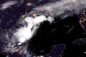
Invest 90L is the latest system now being tracked in the tropical gulf. Although it does not yet have a designation as a tropical depression or tropical storm, it has become sufficiently organized such that forecasters are paying more attention to it.
The designation allows weather agencies to:
- Analyze satellite imagery
- Run computer forecast models
- Monitor storm development
- Issue weather updates
- Assess potential risks to land areas
Because of its location and projected movement, Invest 90L Louisiana and Invest 90L Mississippi impacts have become a major focus for meteorologists.
Latest Invest 90L Update
The latest Invest 90L update suggests the system is gradually becoming more organized while moving toward the northern Gulf Coast.
Meteorologists continue to evaluate:
- Wind circulation patterns
- Thunderstorm activity
- Atmospheric pressure changes
- Sea surface temperatures
- Future development potential
Nevertheless, there’s growing confidence that parts of Louisiana and Mississippi will see heavy rains, whether or not the disturbance becomes a named storm as its strength was still uncertain.
It’s unclear how strong the system will get, but there is growing confidence significant portions of Louisiana and Mississippi will see heavy rains. 98 Although it is the potential for impact from wind that concerns most people, it is the threat of extended periods of heavy rain that is the present worry.
Invest 90L Forecast and Storm Track
According to the latest Invest 90L forecast, the disturbance is expected to move toward the Gulf Coast over the next several days.
Computer models indicate:
- Moisture-rich air moving inland
- Increased rain coverage
- Strong thunderstorms
- Gusty winds near coastal communities
- Elevated flooding concerns
Forecast models still differ in terms of the exact track, but most bring the heaviest impacts over Louisiana and Mississippi.
Since tropical systems are known to make unpredictable shifts, residents are urged to stay tuned to future advisories.
Heavy Rain Threat for Louisiana
The most immediate threat from the Invest 90L Louisiana impact is heavy rainfall.
Forecasters caution that a few places could see a couple of inches of rain in a flash. Possible outcomes are:
Flash Flooding
Urban areas may experience rapid flooding as drainage systems become overwhelmed.
Road Closures
Low-lying roads could become impassable due to standing water.
Travel Disruptions
Heavy rainfall may reduce visibility and create hazardous driving conditions.
Localized Flood Emergencies
Areas with poor drainage are particularly vulnerable to flood-related issues.
The developing heavy rain threat is expected to remain one of the primary hazards associated with the system.
Mississippi Weather Forecast and Potential Impacts
The Mississippi weather forecast also indicates increasing concerns as Invest 90L approaches.
Meteorologists are predicting:
- Periods of intense rainfall
- Thunderstorms
- Strong wind gusts
- Flooding in vulnerable locations
- Dangerous travel conditions
#Humanized Output
There could be spillover effects in other parts of southern Mississippi, but rain bands will most likely be confined to the coast depending on the final track.
Keep watching the skies for advisories and maybe even flood warnings.
Strong Winds Expected Across the Gulf Coast
In addition to heavy rainfall, strong winds expected from Invest 90L could create additional challenges.
Even if the system does not become a tropical storm, gusty conditions may result in:
- Downed tree branches
- Power outages
- Difficult travel conditions
- Coastal hazards
- Rough marine conditions
The larger Gulf Coast weather pattern that includes Invest 90L is expected to bring similar conditions to several states at once.
Those living along the shoreline should be especially alert to future forecasts, as wind conditions could intensify suddenly.
Flooding Risk in Louisiana and Mississippi
One of the broadest worries in the Gulf Coast storm system is flooding.
Tropical Moisture + Repeated Bands of Rain + Saturated Ground can Quickly Add Up to Flooding.
Flooding Risk Louisiana
Forecasters are particularly concerned about:
- Urban flooding
- Small stream flooding
- Poor drainage flooding
- Roadway inundation
Flooding Risk Mississippi
Mississippi communities face similar risks, especially in low-lying regions where heavy rainfall can accumulate quickly.
The possibility of multiple rounds of rain could worsen conditions and increase overall flood potential.
Will Invest 90L Become a Tropical Storm?
One of the most common questions being asked is:
Will Invest 90L become a tropical storm?
At this stage, meteorologists have not ruled out further development.
Several factors could influence whether the disturbance strengthens:
Favorable Conditions
- Warm Gulf waters
- High atmospheric moisture
- Limited wind shear
Unfavorable Conditions
- Interaction with land
- Dry air intrusion
- Upper-level atmospheric disruptions
Regardless of classification, the system remains capable of producing hazardous weather.
This is why the tropical weather update remains important even if the disturbance never receives an official storm name.
National Hurricane Center Monitoring Invest 90L
The National Hurricane Center Invest 90L advisory process continues as forecasters monitor developments around the clock.
The agency is analyzing:
- Satellite imagery
- Aircraft reconnaissance data
- Ocean temperatures
- Atmospheric conditions
- Computer forecast guidance
The NHC will continue issuing updates as new information becomes available.
Residents should rely on official forecasts rather than social media rumors or unofficial weather graphics.
How Residents Should Prepare
With Invest 90L bringing heavy rain to Louisiana and Mississippi, preparation is essential.
Experts recommend:
Stay Informed
Monitor official weather updates frequently.
Prepare Emergency Supplies
Have food, water, flashlights, and batteries available.
Charge Devices
Power outages can occur during strong storms.
Avoid Flooded Roads
Never drive through standing water.
Review Emergency Plans
Ensure family members know what to do if conditions worsen.
Taking action early can significantly reduce risks associated with severe weather.
Frequently Asked Questions
What is Invest 90L?
Invest 90L is a tropical disturbance currently being monitored for possible development in the Gulf region.
Will Invest 90L become a tropical storm?
Development remains possible, but forecasters continue monitoring conditions before making any official classification.
How much rain will Invest 90L bring to Louisiana?
Rainfall totals will vary by location, but heavy rainfall capable of causing flooding remains a primary concern.
What areas are most at risk?
Louisiana and Mississippi currently face the highest threat from heavy rainfall, flooding, and strong winds.
Is the National Hurricane Center tracking Invest 90L?
Yes. The National Hurricane Center continues issuing updates and monitoring the system’s progress.
Final Thoughts
The latest Invest 90L forecast and storm track update suggests that residents across Louisiana and Mississippi should prepare for a period of unsettled and potentially hazardous weather. While questions remain about whether the disturbance will strengthen into a tropical storm, the threats associated with Invest 90L are already becoming clear.
The combination of a heavy rain threat, strong winds expected, and elevated flooding risk in Louisiana and Mississippi makes this a system that should not be ignored. As the National Hurricane Center continues monitoring the disturbance, residents across the Gulf Coast are encouraged to remain informed, follow official advisories, and take preparedness measures seriously.
Whether or not the system receives a name, Invest 90L storm system threatens southern United States communities with potentially disruptive weather, making preparedness and awareness critical in the days ahead.